Note
Go to the end to download the full example code.
Parametric calculation#
- Problem description:
Write a user file macro to calculate the distance
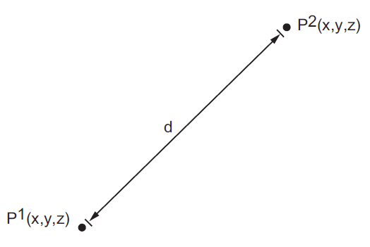
dbetween either nodes or keypoints inPREP7. Define abbreviations for calling the macro and verify the parametric expressions by using the macro to calculate the distance between nodes \(N_1\) and \(N_2\) and between keypoints \(K_3\) and \(K_4\).
- Reference:
None.
- Analysis type(s):
Parametric arithmetic.
- Element type:
None.
- Geometric properties (coordinates):
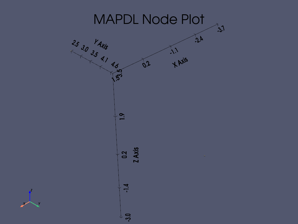
\(N_{\mathrm{1(x,y,z)}} = 1.5, 2.5, 3.5\)
\(N_{\mathrm{2(x,y,z)}} = -3.7, 4.6, -3\)
\(K_{\mathrm{3(x,y,z)}} = 100, 0, 30\)
\(K_{\mathrm{4(x,y,z)}} = -200,25,80\)
- Analysis assumptions and modeling notes:
Instead of
*CREATE,*USE, etc., we have created a classCreatewith methods that correspond to each type of simulation. This class gives a possibility to change coordinates and reuse it. The simulation can be checked not just by target values, but also with the simple distances’ formula between keypoints as:- Calculate distance between two keypoints in the Cartesian coordinate system:
\(D = \sqrt[2]{(x_2 - x_1)^2 + (y_2 - y_1)^2 + (z_2 - z_1)^2}\)
- Python representation of the distance formula:
import math
# Define coordinates for keypoints K3 and K4.
x1, y1, z1 = 100, 0, 30
x2, y2, z2 = -200, 25, 80
dist_kp = math.sqrt((x2 - x1)**2 + (y2 - y1)**2 + (z2 - z1)**2)
print(dist_kp)
# sphinx_gallery_thumbnail_path = '_static/vm8_setup.png'
Start MAPDL#
Start MAPDL and import Numpy and Pandas libraries.
from ansys.mapdl.core import launch_mapdl
import numpy as np
import pandas as pd

# Start MAPDL.
mapdl = launch_mapdl()
Pre-processing#
Enter verification example mode and the pre-processing routine.
mapdl.clear()
mapdl.verify()
mapdl.prep7(mute=True)
Define class#
Identifying the class create with methods create_kp_method and
create_node_method to calculate and plot the distances between keypoints
and nodes.
class Create:
    def __init__(self, p1, p2):
        # Points Attributes.
        self.p1 = p1
        self.p2 = p2

    def kp_distances(self):

        # Define keypoints by coordinates.
        kp1 = mapdl.k(npt=3, x=self.p1[0], y=self.p1[1], z=self.p1[2])
        kp2 = mapdl.k(npt=4, x=self.p2[0], y=self.p2[1], z=self.p2[2])

        # Get the distance between keypoints.
        dist_kp, kx, ky, kz = mapdl.kdist(kp1, kp2)

        # Plot keypoints.
        mapdl.kplot(
            show_keypoint_numbering=True,
            vtk=True,
            background="grey",
            show_bounds=True,
            font_size=26,
        )
        return dist_kp

    def node_distances(self):

        # Define nodes by coordinates.
        node1 = mapdl.n(node=1, x=self.p1[0], y=self.p1[1], z=self.p1[2])
        node2 = mapdl.n(node=2, x=self.p2[0], y=self.p2[1], z=self.p2[2])

        # Get the distance between nodes.
        dist_node, node_x, node_y, node_z = mapdl.ndist(node1, node2)

        # Plot nodes.
        mapdl.nplot(nnum=True, vtk=True, color="grey", show_bounds=True, font_size=26)
        return dist_node

    @property
    def p1(self):
        # Getting value
        return self._p1

    @p1.setter
    def p1(self, new_value):
        # Check the data type:
        if not isinstance(new_value, list):
            raise ValueError("The coordinates should be implemented by the list!")
        # Check the quantity of items:
        if len(new_value) != 3:
            raise ValueError(
                "The coordinates should have three items in the list as [X, Y, Z]"
            )
        self._p1 = new_value

    @property
    def p2(self):
        return self._p2

    @p2.setter
    def p2(self, new_value):
        # Check the data type:
        if not isinstance(new_value, list):
            raise ValueError("The coordinates should be implemented by the list!")
        # Check the quantity of items:
        if len(new_value) != 3:
            raise ValueError(
                "The coordinates should have three items in the list as [X, Y, Z]"
            )
        self._p2 = new_value
Distance between keypoints#
Using already created method for keypoints to get the distance between them and print out an output. The keypoints have got next coordinates:
\(K_{\mathrm{3(x,y,z)}} = 100, 0, 30\)
\(K_{\mathrm{4(x,y,z)}} = -200, 25,80\)
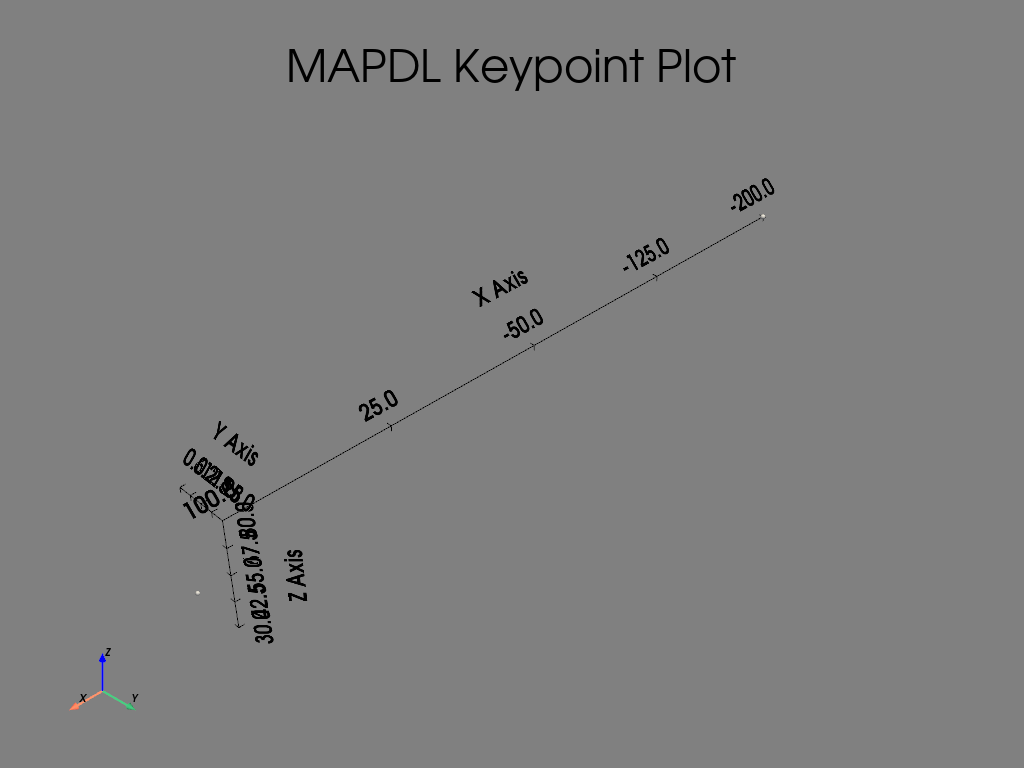
Distance between keypoint is: 305.16


LIST ALL SELECTED KEYPOINTS.   DSYS=      0
   *****MAPDL VERIFICATION RUN ONLY*****
     DO NOT USE RESULTS FOR PRODUCTION

    NO. X,Y,Z LOCATION                   KESIZE     NODE  ELEM MAT REAL TYP ESYS
     3   100.       0.00       30.0       0.00         0     0   0    0   0    0
     4  -200.       25.0       80.0       0.00         0     0   0    0   0    0
Distance between nodes#
Using already created method for nodes to get the distance between them and print out an output. The nodes have got next coordinates:
\(N_{\mathrm{1(x,y,z)}} = 1.5, 2.5, 3.5\)
\(N_{\mathrm{2(x,y,z)}} = -3.7, 4.6, -3\)
[82, 87, 110]
Distance between nodes is: 8.58


LIST ALL SELECTED NODES.   DSYS=      0
   *****MAPDL VERIFICATION RUN ONLY*****
     DO NOT USE RESULTS FOR PRODUCTION

    NODE        X             Y             Z           THXY     THYZ     THZX
        1   1.5000        2.5000        3.5000          0.00     0.00     0.00
        2  -3.7000        4.6000       -3.0000          0.00     0.00     0.00
Check results#
Finally we have the results of the distances for both simulations, which can be compared with expected target values:
1st simulation to get the distance between keypoints \(K_3\) and \(K_4\), where \(LEN_1 = 305.16\,(in)\)
2nd simulation to get the distance between nodes \(N_1\) and \(N_2\), where \(LEN_2 = 8.58\,(in)\)
For better representation of the results we can use pandas dataframe
with following settings below:
# Define the names of the rows.
row_names = ["N1 - N2 distance (LEN2)", "K3 - K4 distance (LEN1)"]

# Define the names of the columns.
col_names = ["Target", "Mechanical APDL", "RATIO"]

# Define the values of the target results.
target_res = np.asarray([8.5849, 305.16])

# Create an array with outputs of the simulations.
simulation_res = np.asarray([node_dist, kp_dist])

# Identifying and filling corresponding columns.
main_columns = {
    "Target": target_res,
    "Mechanical APDL": simulation_res,
    "Ratio": list(np.divide(simulation_res, target_res)),
}

# Create and fill the output dataframe with pandas.
df2 = pd.DataFrame(main_columns, index=row_names).round(2)

# Apply settings for the dataframe.
df2.head()
Stop MAPDL#
mapdl.exit()
Total running time of the script: (0 minutes 1.322 seconds)